Important information about coastal flood maps
A number of local jurisdictions along the coast, including New Hanover County, Brunswick County, Wilmington, and the towns therein, are in the process of adopting their new flood maps and updating their flood ordinances. These maps are critical as they will allow the communities to continue to participate in the National Flood Insurance Program.
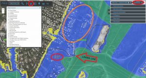
We wanted to draw your immediate attention to one area of the new maps, the LiMWA (Limit of Moderate Wave Action) which will impact properties in the A zone. It is imperative that you recheck your properties to determine if the LiMWA line will impact you. As you can see in the photo below, the homes in the orange circle are in the AE zone, but seaward of the LIMWA. These are the structures to double-check.
Due to a change in the Building Code, being seaward of the LiMWA will essentially require structures in the A zone to have to build to V zone standards. For example, in Wilmington, there are ~350 structures, mostly residences, who appear to be in the A zone (according to the map), BUT due to the LiMWA, will be held to V zone standards if they decide to build a new structure or renovate over a certain threshold. The FEMA Fact Sheet regarding these higher standards can be found here.
These changes may have also affected other coastal communities as well. We are currently reviewing flood maps for those areas to determine additional impact. Regardless of the locations impacted, this is a significant gray area and many property owners may not be fully informed about this classification in the maps and how it could affect them.
- Go to http://fris.nc.gov/fris/Home.aspx?ST=NC
- Input address of property
- Switch to preliminary maps (top right corner)
- Use layers tab to drop down menu, check “LIMWA” box
**Special thanks to Cape Fear REALTORS® for providing this important information
